 |
 |
 |
 |
 |
 |
 |
 |
 |
 |
 |
 |
Project description
Name der Fallstudie
Baglan Energy Park Phase 2
Description of context
? Section 121 of the Government of Wales Act made it a legally binding duty for the National Assembly for Wales to pursue sustainable development in all it does.
? Neath Port Talbot County Borough Unitary Development Plan ? Deposit Draft (January 2003) identifies that the Baglan Bay Development (of which Baglan Energy Park Phase II is a component) is part of the Objective 1 strategic site known as Swansea Bay Arc of Opportunity. Neath Port Talbot have an initiative to regenerate the area and communities as a growth point which it hopes will act as a stimulus to the whole of South West Wales. The aim is to create "a thriving high quality sub-region with an emphasis on raising the quality of life through the area and key regeneration sites". (http://www.npt.gov.uk/udp/index.cfm).
? Neath Port Talbot County Borough Unitary Development Plan ? Deposit Draft (January 2003) states one of the Community Plan Objectives and Targets for employment in the area is: "..large scale employment opportunities will be concentrated on the coastal belt e.g. Baglan Energy Park (providing 3,600 jobs by 2012) ?."
? Neath Port Talbot County Borough Unitary Development Plan (UDP)? Deposit Draft (January 2003) allocates the Baglan Bay Development as sites for " ..business, industry, storage, distribution and offices (financial and professional services). Development that would lead to the loss of the land is either allocated for business development in this plan or has the benefit of planning permission for other uses will only be permitted in exceptional circumstances". The UDP allows the following uses only on the Baglan Bay Development: Financial and Professional Services, Business, General Industry, and Storage and Distribution.
Description of project - background
The site was formerly occupied by BP Chemicals and DuPont Steelworks, the site therefore required clean up of contamination and demolition of existing infrastructure before further development could occur. The site is located on the coast close to Port Talbot and Swansea and is easily accessible by sea and road making it a good location for future development.
Baglan Energy Park is being developed in two phases. Phase 1 is suitable for light manufacturing and service industries. Phase 2 is suitable for both light and heavy manufacturing industries. This case study involves Phase 2 development of Baglan Energy Park which includes land reclamation and installation of essential infrastructure on an 70 hectare site in preparation for occupation.
?9 million has been invested in the remediation work including the installation/repair of basic infrastructure such as transportation facilities, urban drainage system that is considered by the UK Environment Agency as a technique to manage surface and groundwater regimes in a sustainable way to providing a high quality environment. Phase 2 is currently being marketed as "Offering a rolling programme of advanced factory developments and a choice of plots suitable for bespoke construction projects, Baglan Energy Park provides a wide range of manufacturing and office developments" (Baglan Energy Park).
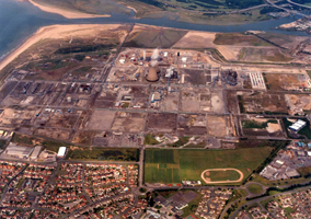
Aerial photo of the Baglan Energy Park site
Baglan Energy Park Phase 2 development took place between January 2000 and August 2002. The steering group for the site comprised Neath Port Talbot County Borough Council (NPTCBC), BP and the Welsh Development Agency (WDA). Phase 2 also involved the contractor Hochtief/Griffiths, an independent consultant, EC Harris (a global consultancy in real estate, infrastructure, industrial and construction sectors), and ARUPS, a building, engineer and infrastructure consultancy.

Remediation works underway
Description of project - objectives/aims
The aim of the project is to produce an area of land that is ready for development including decontamination, structural landscaping and the provision of basic infrastructure for future development. Considerations made include:
1.Transportation of products/waste on and off site during site works to minimise disposal and use of raw materials, including:
? rubble from three cooling towers demolished on site was used to create a protective sea wall,
? waste materials on site such as rubble was used for remediation and structural landscaping and was not therefore sent to landfill.
? the site, because of its size, was divided into sections. Waste material including slag, clinker and ash, was collected from different sections of the site, mixed together and then replaced to disperse contamination problems to acceptable levels,
? a 10m high by 30m wide landscaping bund was created along the southern edge of the site to accommodate materials unsuitable for site filling.
? the minimal amount of special waste was taken off site in oil drums,
? waste material from the reconstruction of the nearby motorway was used as a sub-base for footpaths on site.
2. Drainage mechanisms appropriate to the site were incorporated, in an effort to be more environmentally friendly. ?Swales?, which are grassed depressions directing surface water overland from a drained surface to a discharge system, have been used. These collect surface water run-off which would usually go into the water treatment system but now soaks into the ground reducing the volume of water to be treated. A brook that runs across the site was cleared out and landscaped to add to the visual attractiveness.
3. Transportation ? Road provision has been installed onto site in preparation for future construction. This includes a 1km access route from local main roads. Utilisation of previous transportation infrastructure has been attempted where possible. An existing railway link has been retained to provide a transportation option for future developments.
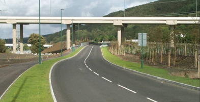
Energy Park Access Road
An existing road bridge did not have sufficient carrying capacity for road traffic and pedestrians/cycles. The existing bridge will be used for vehicles with a smaller second bridge being constructed for pedestrians and bicycles and to carry new service pipes and cables to prevent the expense of removing the old bridge and building a large new one. A nearby dock has been opened with a viewing platform and cycle track to encourage modal shift from car to bicycle.
A 7 hectare area has been allocated for lapwing mitigation, nesting is being stopped in other areas to prevent future disruption. A survey of breeding birds has been carried out annually since 2000, and this will continue to 2007. A Nature Conservation Document has been used to illustrate to developers what should be done with regards to the environment and biodiversity. During redevelopment indigenous plants were moved to a translocation area and the approach to landscaping for phase 2 has involved the use of indigenous species only.
Description of project - time interval and stages
The project began in January 2000, and the land reclamation and installation of essential infrastructure was completed in August 2002. During the project a survey of breeding birds has been carried out annually since 2000, and this will continue to 2007.
Description of project - financing
The total cost of the scheme was ?9 million with ?3 million from European Regional Development Fund (ERDF), ?3 million from the Welsh Development Agency (WDA), ?2 million from BP and ?1 million from NPTCBC.
Description of project - other sectors involved
-
Welche Tools wurden verwendet, um Nachhaltigkeit zu beurteilen?
Environmental Impact Assessment (EIA)
Environmental management system: ISO 14001
Hochtief/Griffiths QUENSH (Quality, Environment, Safety and Health) plan
Key Performance Indicators (KPIs)
Weiterführende Informationen (nur auf Englisch):