 |
 |
 |
 |
 |
 |
 |
 |
 |
 |
 |
 |
Application of tools
Name of the case study
Management of wind-farm developments in Wallonia (landscape and use of land)
Name of tool
EiEolienne planning-map
Description of tool - character
Tools have been developed to better manage the integration of wind-farm developments through Wallonia.
The EiEolienne map is a map that defines zones of the Region where wind-farm developments are excluded or restricted, To define landscape constraints, 4 scales of landscapes (Landscape territory; Large common rural landscape; landscapes unities and local zone) and 2 qualities (heritage value and landscapes? objectives) have been definied. Landscapes? Indicators have been aggregated with other indicators to set up a map that will support the assessment of the location a wind-farm project.
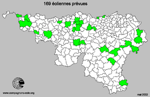
Wallonian municipalities where Wind-farms settlements are planned
Description of tool - availability
Tools are available on electronic and paper formats for free.
Description of tool - existing
Concerning the EiEolienne…
The first idea of a general planning-map (taking into account, for example, electricity networks and wind studies) covering the whole regional territory, indicating the zones where projects could be developed hasfinally been rejected as other countries' experiences showed the results were not relevant enough with regard to the time and money consumed for studies.
A planning-map considering landscapes through Wallonia was also judged not pertinent at the regional scale as landscapes are so varied and numerous. The definition of zones for wind-farm developments is still under debate in Belgium (and in other European countries).
Until now, the tool in use (even if it is not a legal obligatory procedure) is the EIEolienne map. It defines zones in the territory where wind-farms locations are excluded or restricted. The main difference is that the focus is on constraints.
Description of tool - adaptation
Developers of the tools are aware of the local Wallonian context and contact local experts.
Name of tool
Framework of Guidelines for Wind Energy development
Description of tool - character
Tools have been developed to better manage the integration of wind-farm developments through Wallonia.
The Framework of Guidelines for Wind Energy developments is a guideline of adapted technical definitions and solutions for projects. It sets up rules and good practices to be respected in a wind-farm project. The annexes also contain recommendations for developing the EIA.
Description of tool - availability
Tools are available on electronic and paper formats for free.
Description of tool - existing
The Framework for Wind-Farm' developments was developed by the relevant Ministries' departments. Benchmark data and goals were inspired by considerations of other European countries that are leaders in wind-farm development, German and Dutch benchmarks are given.
Description of tool - adaptation
Developers of the tools are aware of the local Wallonian context and contact local experts.
What tools were used to assess sustainability?
Framework of Guidelines for Wind Energy development
More information